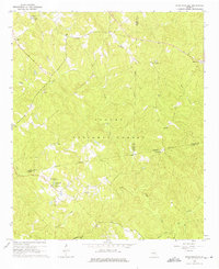
1964 Map of Stanfordville
USGS Topo · Published 1976About this map
The Oconee National Forest covers much of this landscape in central Georgia, where the borders of Jasper, Putnam, and Jones counties converge. Small agricultural settlements like Stanfordville and Goolsby are connected by a network of light-duty roads and a Jeep Trail, centered around local spiritual life at Mt Carmel Ch, Wesley Chapel, and Griggs Chapel. The presence of the Uncle Remus Dist Headquarters near the Hillsboro Lake Recreation Area reflects the administrative and recreational development of the forest lands during the mid-20th century.
Find a feature on this map
25 named features on this map. Tap any name to fly to it.
Don’t see what you’re looking for? This feature index may not catch every label — zoom into the map to look around manually.
Map Details
Editions of this 1964 Stanfordville Map
3 editions found
Other maps of this area

1953 · Athens
USGS Topo · 1:250,000

1958 · Athens
USGS Topo · 1:250,000

1959 · Athens
USGS Topo · 1:250,000

1963 · Athens
USGS Topo · 1:250,000

1964 · Gray
USGS Topo · 1:24,000
1964 · Dames Ferry
USGS Topo · 1:24,000

1964 · Stanfordville
USGS Topo · 1:24,000

1964 · Hillsboro
USGS Topo · 1:24,000

1972 · Monticello
USGS Topo · 1:24,000

1972 · Eatonton
USGS Topo · 1:24,000