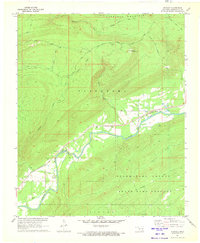
1971 Map of Stanley
USGS Topo · Published 1973About this map
Stanley sits at the heart of this rural landscape, positioned where the St Louis San Francisco railroad follows the winding course of the Kiamichi River. This 1970s survey captures a transition between the river-valley settlement and the high, timbered ridges of Flagpole Mountain to the north. Local history is anchored at the Stanley Cem and a nearby Ford across the river, while the higher elevations are marked by landmarks like Umbrella Rock and the Flagpole Lookout Tower.
Find a feature on this map
28 named features on this map. Tap any name to fly to it.
Don’t see what you’re looking for? This feature index may not catch every label — zoom into the map to look around manually.
Map Details
Editions of this 1971 Stanley Map
This is the sole edition of this map. No revisions or reprints were ever made.
Other maps of this area

1898 · McAlester
USGS Topo · 1:125,000

1901 · Antlers
USGS Topo · 1:125,000

1901 · Tuskahoma
USGS Topo · 1:125,000

1901 · Alikchi
USGS Topo · 1:125,000

1908 · Tuskahoma
USGS Topo · 1:125,000

1909 · Mc Alester
USGS Topo · 1:125,000

1909 · Tuskahoma
USGS Topo · 1:125,000

1912 · Antlers
USGS Topo · 1:125,000

1925 · Antlers
USGS Topo · 1:125,000

1950 · Mcalester
USGS Topo · 1:250,000