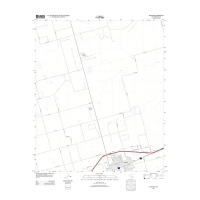
2012 Map of Stanton
USGS Topo · Published 2012About this map
Stanton serves as the focal point of this West Texas landscape, showing a grid of residential and industrial streets south of the Stanton Municipal Airport. The town's layout is defined by thoroughfares such as E St Anna St and W School St, while the surrounding terrain is largely composed of agricultural tracts and industrial facilities like the Permian Basin Encampment. Evidence of the region's agricultural infrastructure is clear near the town's southern edge along Compress Rd. Beyond the developed center, the land is etched by a network of county roads and the intermittent path of Calf Cr, reflecting the arid environment of Martin County where water features are subtle yet significant markers for the community.
Find a feature on this map
46 named features on this map. Tap any name to fly to it.
Don’t see what you’re looking for? This feature index may not catch every label — zoom into the map to look around manually.
Map Details
Editions of this 2012 Stanton Map
This is the sole edition of this map. No revisions or reprints were ever made.
Other maps of this area

1941 · Morita
USGS Topo · 1:62,500

1949 · Morita
USGS Topo · 1:62,500

1954 · Big Spring
USGS Topo · 1:250,000

1958 · Big Spring
USGS Topo · 1:250,000

1966 · Lenorah West
USGS Topo · 1:24,000

1966 · Natural Dam Lake
USGS Topo · 1:24,000
1966 · Germania
USGS Topo · 1:24,000
1966 · Houston Ranch
USGS Topo · 1:24,000

1966 · Stanton
USGS Topo · 1:24,000

1966 · Knott SW
USGS Topo · 1:24,000