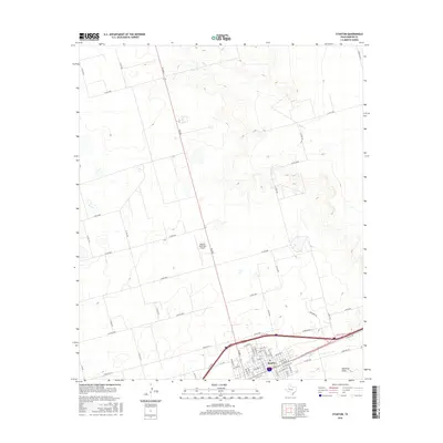
2016 Map of Stanton
USGS Topo · Published 2016About this map
Stanton sits as the focal point of this West Texas landscape, positioned at a critical junction of regional travel and local infrastructure. The community is defined by a traditional grid of streets, including St Anna St and E St Michael St, south of the heavy transport corridor of the I-20 Service Road. North of the town center, the Stanton Municipal Airport serves as a modern landmark amidst the dry drainage patterns of Calf Cr. To the southeast, the terrain transitions toward Hamilton Draw, a significant natural feature in this semi-arid environment. The surrounding area is crisscrossed by an extensive network of rural roads such as Co Rd 2400 and FM 2002, illustrating the reach of the local agricultural and ranching economy. This layout reflects the area's continued reliance on organized transport and the intersection of local residential life with the broader Texas highway system.
Find a feature on this map
61 named features on this map. Tap any name to fly to it.
Don’t see what you’re looking for? This feature index may not catch every label — zoom into the map to look around manually.
Map Details
Editions of this 2016 Stanton Map
This is the sole edition of this map. No revisions or reprints were ever made.
Other maps of this area

1941 · Morita
USGS Topo · 1:62,500

1949 · Morita
USGS Topo · 1:62,500

1954 · Big Spring
USGS Topo · 1:250,000

1958 · Big Spring
USGS Topo · 1:250,000

1966 · Lenorah West
USGS Topo · 1:24,000

1966 · Natural Dam Lake
USGS Topo · 1:24,000
1966 · Germania
USGS Topo · 1:24,000
1966 · Houston Ranch
USGS Topo · 1:24,000

1966 · Stanton
USGS Topo · 1:24,000

1966 · Knott SW
USGS Topo · 1:24,000