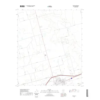
2019 Map of Stanton
USGS Topo · Published 2019About this map
Stanton serves as the central hub of this Martin County landscape, where the traditional street grid intersects with modern transportation corridors like the Interstate 20 service road. The town’s layout is documented down to individual thoroughfares such as Broadway St, St Anna St, and E St Michael St, reflecting the community's organized growth. To the north, the Stanton Municipal Airport stands as a significant landmark, while the surrounding Permian Basin terrain is defined by drainage patterns including Calf Cr and the wide Hamilton Draw. A dense network of county roads, such as Co Rd 2700 and Co Rd 2400, sections the land into a patchwork typical of West Texas agricultural and ranching tracts. This 2019 survey captures the geographic interface between the urban center of the county seat and the vast open spaces that characterize the region.
Find a feature on this map
52 named features on this map. Tap any name to fly to it.
Don’t see what you’re looking for? This feature index may not catch every label — zoom into the map to look around manually.
Map Details
Editions of this 2019 Stanton Map
This is the sole edition of this map. No revisions or reprints were ever made.
Other maps of this area

1941 · Morita
USGS Topo · 1:62,500

1949 · Morita
USGS Topo · 1:62,500

1954 · Big Spring
USGS Topo · 1:250,000

1958 · Big Spring
USGS Topo · 1:250,000

1966 · Lenorah West
USGS Topo · 1:24,000

1966 · Natural Dam Lake
USGS Topo · 1:24,000
1966 · Germania
USGS Topo · 1:24,000
1966 · Houston Ranch
USGS Topo · 1:24,000

1966 · Stanton
USGS Topo · 1:24,000

1966 · Knott SW
USGS Topo · 1:24,000