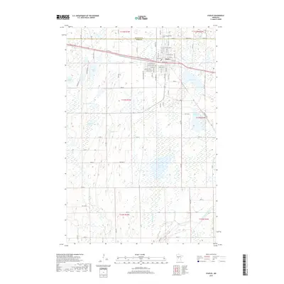
2019 Map of Staples
USGS Topo · Published 2019About this map
Staples serves as the primary hub of this landscape, situated at the boundary of Wadena and Todd counties. The town's grid is well-defined by thoroughfares such as Michigan Ave NE and Dakota Ave, while Evergreen Cem marks the northern outskirts. The surrounding area is characterized by a high density of water bodies, reflecting the glacial heritage of central Minnesota. Significant basins including Dower Lake, Hayden Lake, and Lawrence Lake dot the countryside, connected by waterways like Hayden Cr and the winding Long Prairie River in the southeast. This 2019 survey illustrates a rural-to-urban transition where residential development meets an extensive network of wetlands and drainage systems. Researchers can trace the local infrastructure across several townships, including t133n r33w, where smaller features like Mumm Lake and Jacobson Lake break up the agricultural and forested terrain.
Find a feature on this map
46 named features on this map. Tap any name to fly to it.
Don’t see what you’re looking for? This feature index may not catch every label — zoom into the map to look around manually.
Map Details
Editions of this 2019 Staples Map
This is the sole edition of this map. No revisions or reprints were ever made.
Other maps of this area

1948 · Cushing
USGS Topo · 1:62,500

1950 · Cushing
USGS Topo · 1:62,500

1953 · Brainerd
USGS Topo · 1:250,000

1957 · Brainerd
USGS Topo · 1:250,000

1958 · Brainerd
USGS Topo · 1:250,000

1963 · Motley
USGS Topo · 1:24,000

1965 · Brainerd
USGS Topo · 1:250,000

1966 · Staples NE
USGS Topo · 1:24,000
1966 · Motley NW
USGS Topo · 1:24,000
1966 · Browerville NE
USGS Topo · 1:24,000