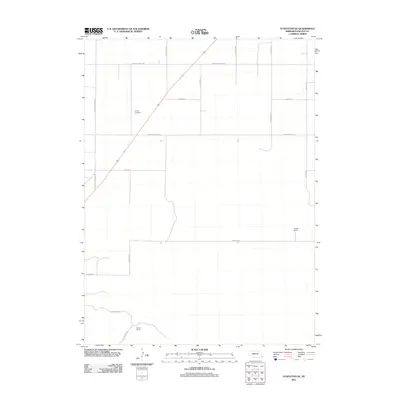
2011 Map of Stapleton SE
USGS Topo · Published 2011About this map
Myrtle Cemetery sits at a high point in the northern section of this Lincoln County landscape, serving as a silent anchor for the surrounding agricultural community. The terrain is organized by a geometric grid of table roads and valley routes, such as E Garfield Table Rd and E Kilmar Valley Rd, which facilitate movement between high plateaus and lower drainage basins. This 2011 survey reveals a territory defined by ranching operations, specifically highlighting the Nowak Ranch to the east and the Stewart Ranch in the south. The road network, including the descriptive N Cattle Growers Rd, underscores the primary economic engine of the region. The spatial arrangement of these ranching outposts and roads reflects a persistent pattern of rural land use in the Nebraska Sandhills periphery, where large-scale operations are managed through a sparse but essential infrastructure of named section lines and family-linked landmarks.
Find a feature on this map
17 named features on this map. Tap any name to fly to it.
Don’t see what you’re looking for? This feature index may not catch every label — zoom into the map to look around manually.
Map Details
Editions of this 2011 Stapleton SE Map
This is the sole edition of this map. No revisions or reprints were ever made.
Other maps of this area

1899 · North Platte
USGS Topo · 1:125,000

1902 · North Platte
USGS Topo · 1:125,000

1954 · North Platte
USGS Topo · 1:250,000

1956 · North Platte
USGS Topo · 1:250,000

1957 · North Platte
USGS Topo · 1:250,000

1967 · North Platte
USGS Topo · 1:250,000

1970 · North Platte East
USGS Topo · 1:24,000
1970 · Maxwell NE
USGS Topo · 1:24,000

1972 · Stapleton NW
USGS Topo · 1:24,000
1972 · Stapleton
USGS Topo · 1:24,000