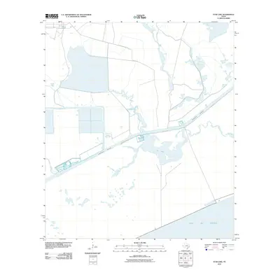
2010 Map of Star Lake
USGS Topo · Published 2010About this map
Star Lake and the surrounding marshlands of Jefferson County define this coastal landscape as it appeared in the early 21st century. The map highlights a complex network of industrial and natural drainage, where the man-made Spindletop Ditch meets the winding Salt Bayou. These waterways serve as critical arteries for the region, positioned just inland from the Gulf of Mexico. The presence of the Intracoastal Waterway cutting through the center of the sheet reflects the enduring importance of maritime transit and shipping for the Texas coast. While largely dominated by wetlands and lakes like Little Lake, the area is accessible by the singular path of Clam Lake Rd, providing a look at the transition between the coastal prairie and the gulf shoreline.
Find a feature on this map
7 named features on this map. Tap any name to fly to it.
Don’t see what you’re looking for? This feature index may not catch every label — zoom into the map to look around manually.
Map Details
Editions of this 2010 Star Lake Map
This is the sole edition of this map. No revisions or reprints were ever made.
Other maps of this area

1950 · Houston
USGS Topo · 1:250,000

1956 · Houston
USGS Topo · 1:250,000

1961 · Star Lake
USGS Topo · 1:24,000

1961 · Mud Lake
USGS Topo · 1:24,000
1961 · Clam Lake
USGS Topo · 1:24,000
1962 · Whites Ranch
USGS Topo · 1:24,000
1962 · Alligator Hole Marsh
USGS Topo · 1:24,000
1962 · South of Star Lake
USGS Topo · 1:24,000
1962 · Hamshire
USGS Topo · 1:24,000
1962 · Big Hill Bayou
USGS Topo · 1:24,000