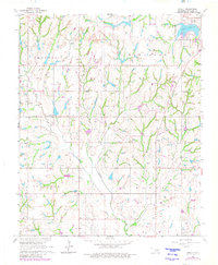
1965 Map of Stealy
USGS Topo · Published 1980About this map
Turkey Creek and Finn Creek carve through this section of McClain County, defining a landscape marked by mid-century petroleum extraction and rural land use. The presence of the West Flint Creek Oil Field, French Oil Field, and an isolated Refinery south of Clagg illustrates the industrial footprint on the prairie. Smaller agricultural operations are evidenced by scattered Gravel Pits and an extensive network of field lines. Local life centers around the settlement of Stealy and spiritual hubs like Bethlehem Ch and Unity Ch. To the northeast, the Purcell Corporate Boundary reaches toward Purcell Lake and Hillside Cemetery, where the terrain flattens out near Chandeer Field.
Find a feature on this map
22 named features on this map. Tap any name to fly to it.
Don’t see what you’re looking for? This feature index may not catch every label — zoom into the map to look around manually.
Map Details
Editions of this 1965 Stealy Map
3 editions found
Other maps of this area

1893 · Norman
USGS Topo · 1:62,500

1898 · Purcell
USGS Topo · 1:125,000

1898 · Pauls Valley
USGS Topo · 1:125,000

1902 · Pauls Valley
USGS Topo · 1:125,000

1902 · Rush Springs
USGS Topo · 1:125,000

1904 · Chickasha
USGS Topo · 1:125,000

1936 · Norman
USGS Topo · 1:62,500

1954 · Oklahoma City
USGS Topo · 1:250,000

1957 · Ardmore
USGS Topo · 1:250,000

1957 · Oklahoma City
USGS Topo · 1:250,000