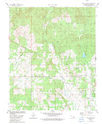
1982 Map of Steel Junction
USGS Topo · Published 1983About this map
The settlement of Oak Hill and the crossroads at Steel Junction anchor this early 1980s landscape in McCurtain County, Oklahoma. The terrain is characterized by a high concentration of small community centers, notably a series of rural churches and family cemeteries that speak to the area's deep-rooted social history. Sites like Towali Ch, Cumberland Ch, and Colbert Chapel are scattered across the low hills, while Watsons Mem Cem and Sweet Home Cem provide clear landmarks for genealogical research.
Find a feature on this map
33 named features on this map. Tap any name to fly to it.
Don’t see what you’re looking for? This feature index may not catch every label — zoom into the map to look around manually.
Map Details
Editions of this 1982 Steel Junction Map
This is the sole edition of this map. No revisions or reprints were ever made.
Other maps of this area

1902 · Lukfata
USGS Topo · 1:125,000

1950 · Mcalester
USGS Topo · 1:250,000

1950 · Idabel
USGS Topo · 1:24,000

1950 · Shults
USGS Topo · 1:24,000

1951 · Idabel
USGS Topo · 1:24,000

1951 · Garvin
USGS Topo · 1:24,000

1951 · Shults
USGS Topo · 1:24,000

1953 · Texarkana
USGS Topo · 1:250,000

1956 · Texarkana
USGS Topo · 1:250,000

1959 · Golden
USGS Topo · 1:62,500