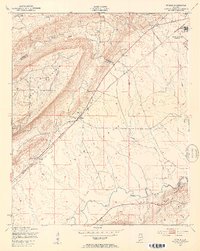
1947 Map of Steele
USGS Topo · Published 1953About this map
Camp Sibert (Abandoned) dominates the northeastern landscape of this postwar survey, highlighting the military footprint in the valley between the Canoe Creek Mountains and Dunaway Mountain. The map illustrates a rural Alabama community defined by its topography and the Southern railway, which serves as a central spine through the town of Steele. Small rural centers and religious landmarks such as Shiloh Ch, Deerman Chapel, and Hopewell Ch are scattered across the terrain, indicating established social hubs for local families. The drainage patterns of Big Canoe Creek and its tributaries reveal the low-lying valley character that dictated settlement near Gilbert and Gallant. This record captures the area just as wartime installations were being phased out, leaving behind structures like the Firing Range and a water tank near Ramsey.
Find a feature on this map
21 named features on this map. Tap any name to fly to it.
Don’t see what you’re looking for? This feature index may not catch every label — zoom into the map to look around manually.
Map Details
Editions of this 1947 Steele Map
3 editions found
Other maps of this area

1885 · Gadsden
USGS Topo · 1:125,000

1888 · Gadsden
USGS Topo · 1:125,000

1889 · Springville
USGS Topo · 1:125,000

1892 · Springville
USGS Topo · 1:125,000

1892 · Gadsden
USGS Topo · 1:125,000

1895 · Gadsden
USGS Topo · 1:125,000

1903 · Gadsden
USGS Topo · 1:125,000

1947 · Cox Gap
USGS Topo · 1:24,000

1947 · Dunaway Mountain
USGS Topo · 1:24,000

1947 · Steele
USGS Topo · 1:24,000