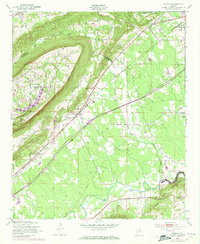
1947 Map of Steele
USGS Topo · Published 1973About this map
Red Mountain and the Canoe Creek Mountains dominate the topography of this Northeast Alabama region, creating a dramatic corridor for transport and settlement. The Southern railroad line cuts diagonally across the landscape, linking the small communities of Steele and Ramsey as it parallels the valley floor. These rails served as a vital artery for the rural economy, situated between the winding paths of Little Canoe Creek and Big Canoe Creek.
Find a feature on this map
23 named features on this map. Tap any name to fly to it.
Don’t see what you’re looking for? This feature index may not catch every label — zoom into the map to look around manually.
Map Details
Editions of this 1947 Steele Map
3 editions found
Other maps of this area

1885 · Gadsden
USGS Topo · 1:125,000

1888 · Gadsden
USGS Topo · 1:125,000

1889 · Springville
USGS Topo · 1:125,000

1892 · Springville
USGS Topo · 1:125,000

1892 · Gadsden
USGS Topo · 1:125,000

1895 · Gadsden
USGS Topo · 1:125,000

1903 · Gadsden
USGS Topo · 1:125,000

1947 · Cox Gap
USGS Topo · 1:24,000

1947 · Dunaway Mountain
USGS Topo · 1:24,000

1947 · Steele
USGS Topo · 1:24,000