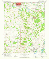
1965 Map of Steeleville
USGS Topo · Published 1966About this map
Sparta and Steeleville anchor this mid-1960s survey of Randolph County, revealing a landscape defined by both industrial activity and rural community roots. The region's coal legacy is evidenced by a prominent Strip Mine and a nearby Mine Dump north of Marys River, while the local social fabric is visible through features like the Fairground in Sparta and a Drive-in Theater situated along the highway to the south.
Find a feature on this map
32 named features on this map. Tap any name to fly to it.
Don’t see what you’re looking for? This feature index may not catch every label — zoom into the map to look around manually.
Map Details
Editions of this 1965 Steeleville Map
2 editions found
Other maps of this area

1912 · Baldwin
USGS Topo · 1:62,500

1914 · Baldwin
USGS Topo · 1:62,500

1914 · Coulterville
USGS Topo · 1:62,500

1915 · Chester
USGS Topo · 1:62,500

1916 · Campbell Hill
USGS Topo · 1:62,500

1917 · Coulterville
USGS Topo · 1:62,500

1918 · Campbell Hill
USGS Topo · 1:62,500

1942 · Baldwin
USGS Topo · 1:62,500

1947 · Chester
USGS Topo · 1:62,500

1949 · Paducah
USGS Topo · 1:250,000