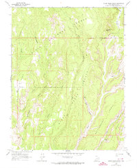
1964 Map of Steep Creek Bench
USGS Topo · Published 1974About this map
Dixie National Forest defines this high-desert landscape in Garfield County, captured through aerial photography and field checking during the mid-1960s. The terrain is characterized by expansive mesas and deep drainage systems, including Steep Creek Bench and the prominent Circle Cliffs. Evidence of early cattle ranching and backcountry traversal is visible through the isolated Long Neck Cabin and an extensive network of Pack Trails and Jeep Trails that navigate the labyrinthine canyons. Water sources are vital landmarks in this arid environment, with Frisky Creek, Steep Creek, and various Springs providing essential stops for travelers. The map illustrates a period before modern development, focusing on the natural geomorphology from Impossible Peak down into the winding depths of The Gulch and Rattlesnake Canyon.
Find a feature on this map
23 named features on this map. Tap any name to fly to it.
Don’t see what you’re looking for? This feature index may not catch every label — zoom into the map to look around manually.
Map Details
Editions of this 1964 Steep Creek Bench Map
3 editions found
Other maps of this area

1885 · Fish Lake
USGS Topo · 1:250,000

1886 · Escalante
USGS Topo · 1:250,000

1896 · Fish Lake
USGS Topo · 1:250,000

1952 · Notom 3 SW
USGS Topo · 1:24,000

1952 · Notom 4 SW
USGS Topo · 1:24,000

1952 · Notom 3 SE
USGS Topo · 1:24,000

1952 · Grover
USGS Topo · 1:62,500

1952 · Notom
USGS Topo · 1:62,500

1953 · Circle Cliffs 2 NE
USGS Topo · 1:24,000

1953 · Circle Cliffs 1 SW
USGS Topo · 1:24,000