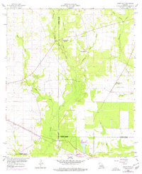
1959 Map of Steep Gully
USGS Topo · Published 1976About this map
The convergence of Vernon, Rapides, and Allen Parishes forms the backbone of this mid-century survey, a landscape defined by its rural community centers and watercourses. Small wood-frame churches and local burial grounds, such as Occupy Ch No 1 and Tenmile Cem, are scattered throughout the wooded terrain, indicating a dispersed but established settlement pattern. The industrial footprint of the era is represented by the Atchison Topeka and Santa Fe railroad corridor, which cuts diagonally across the landscape near Tenmile Creek. Notable landmarks like the Plainview Lookout Tower and Plainview Sch suggest a geography centered on resource management and local education. The map's network of gullys and branches, including Steep Gully and Hickory Log Gully, illustrates the intricate drainage systems that dictated the placement of early homesteads and transportation routes.
Find a feature on this map
22 named features on this map. Tap any name to fly to it.
Don’t see what you’re looking for? This feature index may not catch every label — zoom into the map to look around manually.
Map Details
Editions of this 1959 Steep Gully Map
3 editions found
Other maps of this area

1935 · Pawnee
USGS Topo · 1:31,680

1935 · Oakdale
USGS Topo · 1:31,680

1942 · Oakdale
USGS Topo · 1:62,500

1943 · Leander
USGS Topo · 1:62,500

1947 · Steep Gully
USGS Topo · 1:31,680

1947 · Elizabeth
USGS Topo · 1:31,680

1947 · Grant
USGS Topo · 1:31,680

1947 · Pitkin
USGS Topo · 1:31,680

1948 · Grant
USGS Topo · 1:24,000

1948 · Elizabeth
USGS Topo · 1:24,000