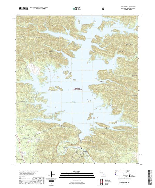
2022 Map of Stephens Gap
USGS Topo · Published 2022About this map
Broken Bow Lake dominates the central landscape of this McCurtain County region, where the impounded waters of the Mountain Fork river create a complex shoreline of deep coves and timbered ridges. Within the protected expanse of the Ouachita National Forest, the topography rises sharply to landmarks such as Bee Creek Mtn, Ashford Peak, and the Devils Backbone. The settlement at Hochatown sits near the northern reaches of Hochatown State Park, while the southern end of the map traces the rugged river bend at Beaver Bend State Park, known for the steep Rattlesnake Bluff. This contemporary survey reflects the area's transition into a major recreation hub, with numerous local access points like Old Hochatown Rd and Carson Cr Rd providing entry to the dense forest and water-rich terrain that has long defined this corner of Oklahoma.
Find a feature on this map
64 named features on this map. Tap any name to fly to it.
Don’t see what you’re looking for? This feature index may not catch every label — zoom into the map to look around manually.
Map Details
Editions of this 2022 Stephens Gap Map
This is the sole edition of this map. No revisions or reprints were ever made.
Other maps of this area

1902 · Lukfata
USGS Topo · 1:125,000

1950 · Mcalester
USGS Topo · 1:250,000

1959 · Golden
USGS Topo · 1:62,500

1959 · Broken Bow
USGS Topo · 1:62,500

1960 · Bethel
USGS Topo · 1:62,500

1960 · Smithville
USGS Topo · 1:62,500

1962 · McAlester
USGS Topo · 1:250,000

1965 · McAlester
USGS Topo · 1:250,000
1976 · Broken bow NE
USGS Topo · 1:24,000
1976 · Broken Bow SW
USGS Topo · 1:24,000