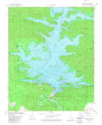
1981 Map of Stephens Gap
USGS Topo · Published 1981About this map
Broken Bow Lake dominates the central landscape of this McCurtain County region, having recently reshaped the topography through the damming of the Mountain Fork. The map documents a significant era of recreation development, showing the extensive infrastructure of Hochatown State Park and Beavers Bend State Park. The small settlement of Hochatown sits on the western edge, with nearby Cem providing a link to the community's earlier history before the reservoir's expansion. Significant elevations like Sulphur Mountain and Eagle Mountain frame the water, while the southern reach reveals the winding path of the river below the dam at Beavers Bend. Local landmarks such as Devils Backbone and Battlesnake Bluff highlight the prominent ridgelines that survived the flooding of the valley.
Find a feature on this map
58 named features on this map. Tap any name to fly to it.
Don’t see what you’re looking for? This feature index may not catch every label — zoom into the map to look around manually.
Map Details
Editions of this 1981 Stephens Gap Map
This is the sole edition of this map. No revisions or reprints were ever made.
Other maps of this area

1902 · Lukfata
USGS Topo · 1:125,000

1950 · Mcalester
USGS Topo · 1:250,000

1959 · Golden
USGS Topo · 1:62,500

1959 · Broken Bow
USGS Topo · 1:62,500

1960 · Bethel
USGS Topo · 1:62,500

1960 · Smithville
USGS Topo · 1:62,500

1962 · McAlester
USGS Topo · 1:250,000

1965 · McAlester
USGS Topo · 1:250,000
1976 · Broken bow NE
USGS Topo · 1:24,000
1976 · Broken Bow SW
USGS Topo · 1:24,000