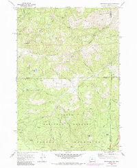
1968 Map of Stephenson Mtn.
USGS Topo · Published 1985About this map
Stephenson Mountain and the high ridges of the Ochoco Mountains dominate this high-elevation terrain within the Ochoco National Forest. The landscape is a network of ridges and deep drainages, including Bear Creek and Taylor Creek, where mining and ranching interests left their mark. Notable historic sites include the Old Stephenson Ranch and the remote Ludwick Cabin near Red Rock Pass.
Find a feature on this map
43 named features on this map. Tap any name to fly to it.
Don’t see what you’re looking for? This feature index may not catch every label — zoom into the map to look around manually.
Map Details
Editions of this 1968 Stephenson Mtn. Map
2 editions found

Other maps of this area

1926 · Mitchell
USGS Topo · 1:125,000

1948 · Ochoco Reservoir
USGS Topo · 1:62,500

1950 · Ochoco Reservoir
USGS Topo · 1:62,500

1951 · Lookout Mtn
USGS Topo · 1:62,500

1955 · Bend
USGS Topo · 1:250,000

1957 · Bend
USGS Topo · 1:250,000

1958 · Bend
USGS Topo · 1:250,000

1968 · Horse Heaven Creek
USGS Topo · 1:24,000

1968 · Painted Hills
USGS Topo · 1:24,000

1968 · Lawson Mtn
USGS Topo · 1:24,000