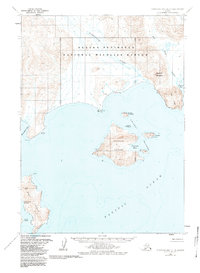
1963 Map of Stepovak Bay D-4
USGS Topo · Published 1984About this map
Perryville sits on the southern edge of the Alaska Peninsula, serving as a focal point for settlement along this coastal stretch of the Pacific Ocean. The village is situated near the mouth of the Kametolook River, with a local Landing Strip providing a vital connection to the surrounding wilderness. To the south, the Chiachi Islands dominate the maritime landscape, featuring the large landmass of Chiachi Island and the protected waters of Chiachi Bay.
Find a feature on this map
25 named features on this map. Tap any name to fly to it.
Don’t see what you’re looking for? This feature index may not catch every label — zoom into the map to look around manually.
Map Details
Editions of this 1963 Stepovak Bay D-4 Map
2 editions found
Other maps of this area

1951 · Stepovak Bay
USGS Topo · 1:250,000

1963 · Chignik A-4
USGS Topo · 1:63,360
1963 · Stepovak Bay C-5 and C-6
USGS Topo · 1:63,360

1963 · Stepovak Bay D-4
USGS Topo · 1:63,360

1963 · Chignik A-5
USGS Topo · 1:63,360

1963 · Chignik A-3
USGS Topo · 1:63,360

1963 · Stepovak Bay D-5
USGS Topo · 1:63,360

1963 · Chignik
USGS Topo · 1:250,000
1963 · Stepovak Bay D-3
USGS Topo · 1:63,360

1963 · Stepovak Bay
USGS Topo · 1:250,000