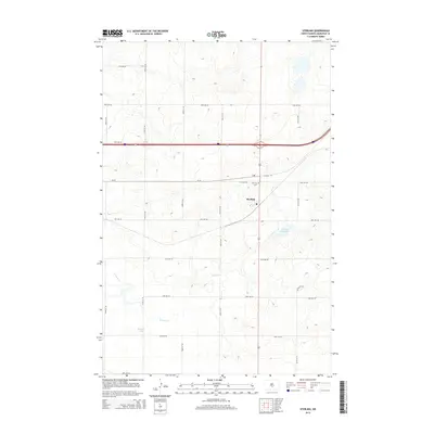
2014 Map of Sterling
USGS Topo · Published 2014About this map
The settlement of Sterling anchors this portion of Burleigh County, situated at a major transportation junction in the North Dakota prairie. The map details a landscape defined by its grid-based agricultural roads, including 57th Ave NE and Lincoln Rd, which segment the rolling terrain into expansive sections. Water features provide distinct landmarks in this otherwise uniform topography, most notably Sterling Reservoir to the east and the winding course of Random Cr which feeds into Random Lake. Local history is anchored by the Sterling Cem and the central Po, reflecting the community infrastructure serving the surrounding rural sections during the early 21st century. The map effectively captures the intersection of major transit corridors with the persistent patterns of Great Plains land division.
Find a feature on this map
28 named features on this map. Tap any name to fly to it.
Don’t see what you’re looking for? This feature index may not catch every label — zoom into the map to look around manually.
Map Details
Editions of this 2014 Sterling Map
This is the sole edition of this map. No revisions or reprints were ever made.
Other maps of this area

1951 · McKenzie
USGS Topo · 1:62,500

1951 · Driscoll
USGS Topo · 1:62,500

1954 · Bismarck
USGS Topo · 1:250,000

1958 · Bismarck
USGS Topo · 1:250,000

1971 · Moffit NW
USGS Topo · 1:24,000

1971 · Moffit
USGS Topo · 1:24,000

1975 · McKenzie
USGS Topo · 1:24,000

1975 · Sibley Butte
USGS Topo · 1:24,000

1975 · Sterling
USGS Topo · 1:24,000
1975 · McKenzie NW
USGS Topo · 1:24,000