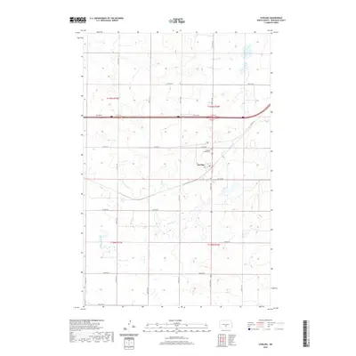
2020 Map of Sterling
USGS Topo · Published 2020About this map
Sterling serves as the central hub of this Burleigh County landscape, situated along the intersection of Co Hwy 10 and several local arterial roads. The settlement is anchored by local landmarks including the Po and the Sterling Union Cem located just to the north. The surrounding terrain is defined by a dense network of sectional roads and the meandering path of Random Creek, which flows through the southern half of the quadrangle. This area reflects a classic North Dakota agricultural layout, where the township and range system dictated a rigid grid of transit like Lincoln Rd and 30th Ave Ne, punctuated by small wetlands and intermittent drainage patterns. The map highlights the enduring structure of rural communities where the post office and cemetery remain vital touchstones of local identity.
Find a feature on this map
28 named features on this map. Tap any name to fly to it.
Don’t see what you’re looking for? This feature index may not catch every label — zoom into the map to look around manually.
Map Details
Editions of this 2020 Sterling Map
This is the sole edition of this map. No revisions or reprints were ever made.
Other maps of this area

1951 · McKenzie
USGS Topo · 1:62,500

1951 · Driscoll
USGS Topo · 1:62,500

1954 · Bismarck
USGS Topo · 1:250,000

1958 · Bismarck
USGS Topo · 1:250,000

1971 · Moffit NW
USGS Topo · 1:24,000

1971 · Moffit
USGS Topo · 1:24,000

1975 · McKenzie
USGS Topo · 1:24,000

1975 · Sibley Butte
USGS Topo · 1:24,000

1975 · Sterling
USGS Topo · 1:24,000
1975 · McKenzie NW
USGS Topo · 1:24,000