Loading...
Loading map...1954 Map of Sterling
USGS Topo · Published 1964About this map
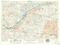
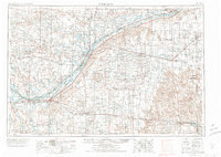
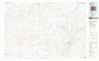
The South Platte River valley dictates the orientation of life across the high plains of northeastern Colorado, as shown in this mid-century survey. Irrigation infrastructure is central to the region's agricultural viability, with the North Sterling Canal and several major ditches like Settlers Ditch and Harmony Ditch Number 1 diverting water from the river to support local farms. Large bodies of water such as Sterling Reservoir, Prewitt Reservoir, and Julesburg Reservoir provide critical storage in this arid environment.
Find a feature on this map
121 named features on this map. Tap any name to fly to it.
Don’t see what you’re looking for? This feature index may not catch every label — zoom into the map to look around manually.
Map Details
Date Portrayed1954
Date Published1964
PublisherU.S. Geological Survey
Map TypeTopographic
Scale1:250,000
Physical Dimensions29.3 x 22.2 inches
Editions of this 1954 Sterling Map
3 editions found

Historical Maps of Sterling Through Time

Featured Locations
Source Details
SourceU.S. Geological Survey
CopyrightPublic Domain