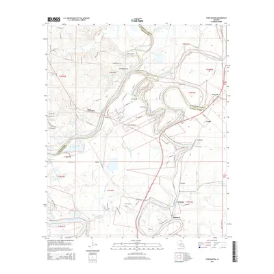
2015 Map of Sterlington
USGS Topo · Published 2015About this map
Ouachita River meanders through this landscape at the intersection of Union, Morehouse, and Ouachita Parishes, defining a region where water and land are inextricably linked. The settlement of Sterlington and its nearby communities like Ouachita City, De Siard, and Fairbanks follow the natural curves of the river and Bayou Bartholomew. The terrain is marked by distinctive hydrological features such as Davis Bend and Morehouse Point, illustrating how the waterway has historically shaped habitation and land use. Genealogists will find an unusually dense concentration of burial sites, including Cook Cem, Thompson Cem, and Bartholomew Cem, which anchor the history of these riverfront communities. The transport network, including Highway 2 and various local routes like Old Sterlington Rd, connects these scattered settlements across the fertile lowlands.
Find a feature on this map
107 named features on this map. Tap any name to fly to it.
Don’t see what you’re looking for? This feature index may not catch every label — zoom into the map to look around manually.
Map Details
Editions of this 2015 Sterlington Map
This is the sole edition of this map. No revisions or reprints were ever made.
Other maps of this area

1935 · Collinston
USGS Topo · 1:62,500

1935 · Naff
USGS Topo · 1:62,500

1935 · Drew
USGS Topo · 1:62,500

1935 · Haile
USGS Topo · 1:62,500

1955 · Jackson
USGS Topo · 1:250,000

1955 · Shreveport
USGS Topo · 1:250,000

1956 · Shreveport
USGS Topo · 1:250,000

1956 · Bastrop
USGS Topo · 1:62,500

1956 · Haile
USGS Topo · 1:62,500

1957 · Monroe North
USGS Topo · 1:62,500