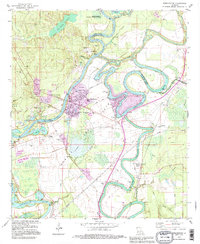
1994 Map of Sterlington
USGS Topo · Published 1995About this map
Ouachita River navigation and industrial development define this mid-1990s landscape at the intersection of Union, Morehouse, and Ouachita Parishes. The township of Sterlington is a central hub of activity, anchored by a prominent Chemical Plant, Powerplant, and a network of Industrial Waste Ponds. This industrial core contrasts with the rural heritage preserved nearby at Glendora Plantation and the Upper Ouachita National Wildlife Refuge to the north.
Find a feature on this map
66 named features on this map. Tap any name to fly to it.
Don’t see what you’re looking for? This feature index may not catch every label — zoom into the map to look around manually.
Map Details
Editions of this 1994 Sterlington Map
This is the sole edition of this map. No revisions or reprints were ever made.
Other maps of this area

1935 · Collinston
USGS Topo · 1:62,500

1935 · Naff
USGS Topo · 1:62,500

1935 · Drew
USGS Topo · 1:62,500

1935 · Haile
USGS Topo · 1:62,500

1955 · Jackson
USGS Topo · 1:250,000

1955 · Shreveport
USGS Topo · 1:250,000

1956 · Shreveport
USGS Topo · 1:250,000

1956 · Bastrop
USGS Topo · 1:62,500

1956 · Haile
USGS Topo · 1:62,500

1957 · Monroe North
USGS Topo · 1:62,500