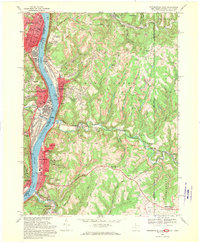
1968 Map of Steubenville East
USGS Topo · Published 1970About this map
The Ohio River corridor serves as the industrial and social backbone of this border region during the late 1960s, linking the steel and manufacturing centers of Steubenville, Follansbee, and Wellsburg. The landscape is defined by the sharp contrast between the densely developed riverfront, marked by the Penn Central and Norfolk and Western railroads, and the deeply incised valleys of the interior. High on the bluffs, residential developments like Hooverson Heights and Archer Heights overlook the heavy industry below, while the surrounding hillsides are scarred by numerous strip mines that reveal the era's reliance on local coal extraction.
Find a feature on this map
81 named features on this map. Tap any name to fly to it.
Don’t see what you’re looking for? This feature index may not catch every label — zoom into the map to look around manually.
Map Details
Editions of this 1968 Steubenville East Map
3 editions found
Other maps of this area

1902 · Wheeling
USGS Topo · 1:62,500

1904 · Steubenville
USGS Topo · 1:62,500

1904 · Burgettstown
USGS Topo · 1:62,500

1906 · Burgettstown
USGS Topo · 1:62,500

1907 · Claysville
USGS Topo · 1:62,500

1935 · Wheeling
USGS Topo · 1:62,500

1935 · Steubenville
USGS Topo · 1:62,500

1942 · Wheeling
USGS Topo · 1:62,500

1942 · Steubenville
USGS Topo · 1:62,500

1951 · Canton
USGS Topo · 1:250,000