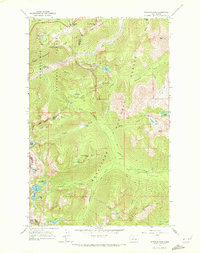
1965 Map of Stevens Pass
USGS Topo · Published 1972About this map
The high alpine divide of the Washington Cascades is documented here in the mid-1960s, centered on the critical transportation corridor of Stevens Pass. The map highlights the engineered mastery of the Great Northern railway, showing its long tunnel beneath the ridgeline and its winding path through the mountains near Cowboy Mtn. Modern transit is represented by U.S. 2, which follows the path of the Tye River through the pass.
Find a feature on this map
50 named features on this map. Tap any name to fly to it.
Don’t see what you’re looking for? This feature index may not catch every label — zoom into the map to look around manually.
Map Details
Editions of this 1965 Stevens Pass Map
5 editions found
Other maps of this area

1901 · Chiwaukum
USGS Topo · 1:125,000

1902 · Skykomish
USGS Topo · 1:125,000

1904 · Chiwaukum
USGS Topo · 1:125,000

1905 · Skykomish
USGS Topo · 1:125,000

1957 · Wenatchee
USGS Topo · 1:250,000

1965 · Captain Point
USGS Topo · 1:24,000

1965 · Chiwaukum Mts
USGS Topo · 1:62,500

1965 · Stevens Pass
USGS Topo · 1:24,000

1965 · Mount Daniel
USGS Topo · 1:24,000

1965 · Wenatchee Lake
USGS Topo · 1:62,500