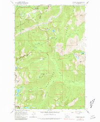
1965 Map of Stevens Pass
USGS Topo · Published 1981About this map
Stevens Pass Guard Station anchors this 1965 survey of the high-altitude divide between the Snoqualmie and Wenatchee National Forests. The landscape is dominated by the engineering legacy of the Great Northern railroad, which utilizes a massive tunnel beneath the ridgeline to bypass the formidable terrain of Big Chief Mtn and Cowboy Mtn. The transition from rail-and-timber industry to recreation is visible through the Stevens Pass ski area and the networks of the Cascade Crest Trail and various pack trails that connect high alpine waters like Josephine Lake and Lake Lorraine. The presence of Bark Cabin along Icicle Creek suggests the era's backcountry management, while landmarks like The Barrier and Bulls Tooth reflect the distinctive nomenclature of the Central Cascades wilderness at the King and Chelan County border.
Find a feature on this map
47 named features on this map. Tap any name to fly to it.
Don’t see what you’re looking for? This feature index may not catch every label — zoom into the map to look around manually.
Map Details
Editions of this 1965 Stevens Pass Map
5 editions found
Other maps of this area

1901 · Chiwaukum
USGS Topo · 1:125,000

1902 · Skykomish
USGS Topo · 1:125,000

1904 · Chiwaukum
USGS Topo · 1:125,000

1905 · Skykomish
USGS Topo · 1:125,000

1957 · Wenatchee
USGS Topo · 1:250,000

1965 · Captain Point
USGS Topo · 1:24,000

1965 · Chiwaukum Mts
USGS Topo · 1:62,500

1965 · Stevens Pass
USGS Topo · 1:24,000

1965 · Mount Daniel
USGS Topo · 1:24,000

1965 · Wenatchee Lake
USGS Topo · 1:62,500