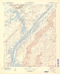
1950 Map of Stevenson
USGS Topo · Published 1950About this map
Stevenson serves as a central hub at the convergence of the Southern and N C & ST L railroads, positioned just north of the massive waters of the Guntersville Reservoir. This mid-century survey illustrates the transformative impact of the Tennessee River valley's development, where the Guntersville Reservoir Boundary weaves through a landscape defined by sharp elevation changes from the river bottom to the heights of Sand Mountain.
Find a feature on this map
59 named features on this map. Tap any name to fly to it.
Don’t see what you’re looking for? This feature index may not catch every label — zoom into the map to look around manually.
Map Details
Editions of this 1950 Stevenson Map
2 editions found
Other maps of this area

1886 · Stevenson
USGS Topo · 1:125,000

1892 · Stevenson
USGS Topo · 1:125,000

1895 · Stevenson
USGS Topo · 1:125,000

1936 · Ider
USGS Topo · 1:24,000

1936 · Bridgeport
USGS Topo · 1:24,000

1936 · Wannville
USGS Topo · 1:24,000

1936 · Flat Rock
USGS Topo · 1:24,000

1936 · Hollywood
USGS Topo · 1:24,000

1936 · Stevenson
USGS Topo · 1:24,000
1936 · Henagar
USGS Topo · 1:24,000