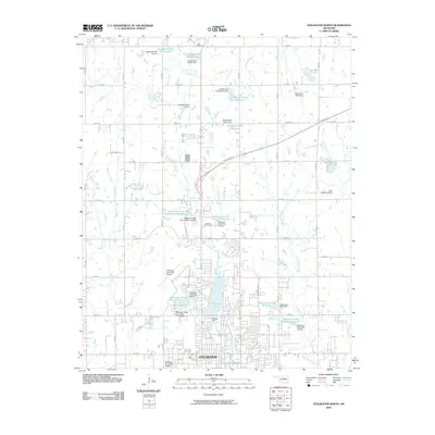
2009 Map of Stillwater North
USGS Topo · Published 2009About this map
Stillwater expands northward in this 2009 survey, showcasing a landscape defined by an intricate network of water management and transportation. The northern edge of the city is anchored by Boomer Lake and the adjacent Sanborn Lake, while the suburban transition is marked by the Stillwater Municipal Airport and Lakeside Golf Course. This era illustrates a highly engineered watershed, where numerous flood control structures like Stillwater Creek Site 24 Reservoir and Longbranch Site 6a Reservoir dot the drainage basins of Cow Creek and Long Branch. The presence of the Cimarron Tpke cutting across the northern reaches reflects the region's connection to the broader Oklahoma transit corridor. Local infrastructure is further detailed through a dense grid of rural routes such as E 0530 Rd and N 3300 Rd, which provide a clear view of the area's land division and residential development patterns outside the city core.
Find a feature on this map
59 named features on this map. Tap any name to fly to it.
Don’t see what you’re looking for? This feature index may not catch every label — zoom into the map to look around manually.
Map Details
Editions of this 2009 Stillwater North Map
This is the sole edition of this map. No revisions or reprints were ever made.
Other maps of this area

1893 · Stillwater
USGS Topo · 1:62,500

1929 · Ripley
USGS Topo · 1:62,500

1930 · Pawnee
USGS Topo · 1:62,500

1932 · Ripley
USGS Topo · 1:62,500

1936 · Pawnee
USGS Topo · 1:62,500

1955 · Enid
USGS Topo · 1:250,000

1958 · Enid
USGS Topo · 1:250,000

1966 · Lake Carl Blackwell
USGS Topo · 1:24,000
1967 · Stillwater North
USGS Topo · 1:24,000
1967 · Stillwater South
USGS Topo · 1:24,000