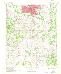
1967 Map of Stillwater South
USGS Topo · Published 1968About this map
Oklahoma State University anchors the northern edge of this mid-century survey, surrounded by the growing residential blocks of Stillwater. South of the campus and its many city parks, the landscape transitions into a production-heavy rural expanse defined by energy extraction and agriculture. The southern half of the map is dominated by the Lost Creek Oil Field and the North Perkins Oil Field, where numerous oil wells and pipelines are marked across the townships of Elm Grove and Clayton. Transportation history is visible along an Old Railroad Grade that follows the winding path of Stillwater Creek. Genealogists will find significant local records in the locations of Fairlawn Cemetery and Elm Grove Cem, alongside several country schools like Pleasant View Sch that served the outlying farming communities before modernization.
Find a feature on this map
43 named features on this map. Tap any name to fly to it.
Don’t see what you’re looking for? This feature index may not catch every label — zoom into the map to look around manually.
Map Details
Editions of this 1967 Stillwater South Map
2 editions found
Other maps of this area

1893 · Stillwater
USGS Topo · 1:62,500

1908 · Agra
USGS Topo · 1:62,500

1909 · Perkins
USGS Topo · 1:62,500

1929 · Ripley
USGS Topo · 1:62,500

1932 · Ripley
USGS Topo · 1:62,500

1954 · Oklahoma City
USGS Topo · 1:250,000

1955 · Enid
USGS Topo · 1:250,000

1957 · Oklahoma City
USGS Topo · 1:250,000

1958 · Enid
USGS Topo · 1:250,000

1963 · Oklahoma City
USGS Topo · 1:250,000