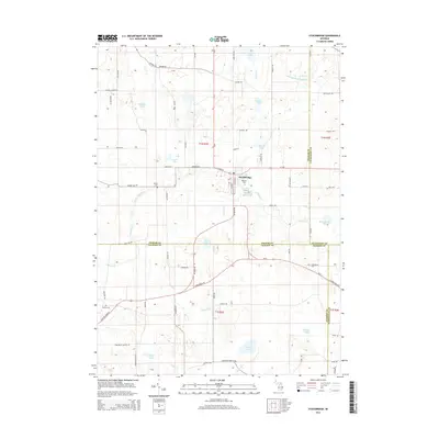
2014 Map of Stockbridge
USGS Topo · Published 2014About this map
Stockbridge serves as the central hub of this South Michigan landscape, where the convergence of M-106 and local routes like S Center St defines the village's footprint. The surrounding terrain is heavily influenced by glacial legacies, evidenced by the numerous kettle lakes and wetland drains scattered across the Ingham, Jackson, and Livingston county lines. Waterways like the Portage River and Thornapple Cr wind through the township, connecting water bodies such as Lowe Lake and Jacobs Lake. Genealogists will find significant value in the distribution of rural burial grounds, including Oaklawn Cem near the village center and the outlying Derby Cem and N Waterloo Cem. The road network follows a rigid grid of historical sections, with family-named thoroughfares like Milner Rd and Dexter Trl providing access to the fertile agricultural lands that characterize this portion of the region.
Find a feature on this map
76 named features on this map. Tap any name to fly to it.
Don’t see what you’re looking for? This feature index may not catch every label — zoom into the map to look around manually.
Map Details
Editions of this 2014 Stockbridge Map
This is the sole edition of this map. No revisions or reprints were ever made.
Other maps of this area

1908 · Fowlerville
USGS Topo · 1:62,500

1909 · Mason
USGS Topo · 1:62,500

1910 · Fowlerville
USGS Topo · 1:62,500

1911 · Mason
USGS Topo · 1:62,500

1919 · Stockbridge
USGS Topo · 1:62,500

1919 · Rives Junction
USGS Topo · 1:62,500

1921 · Rives Junction
USGS Topo · 1:62,500

1922 · Stockbridge
USGS Topo · 1:62,500

1942 · Stockbridge
USGS Topo · 1:62,500

1958 · Grand Rapids
USGS Topo · 1:250,000
Featured Places
- Unadilla Township, MI
- Lyndon Township, MI
- Stockbridge, MI
- Waterloo Township, MI
- Stockbridge Township, MI