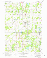
1973 Map of Stockbridge
USGS Topo · Published 1977About this map
The village of Stockbridge sits at the intersection of local routes in this early 1970s survey, showing a landscape defined by glacial lakes and marshes at the junction of Ingham, Livingston, and Jackson Counties. The topography is marked by numerous kettle lakes, including Lowe Lake, Jones Lake, and Nichols Lake, while the expansive Portage Lake Swamp dominates the southeastern quadrant. An Old Railroad Grade traces a path through the terrain, signaling a shift from earlier rail-dependent commerce to a more modern road network including Base Line and Territorial Road.
Find a feature on this map
80 named features on this map. Tap any name to fly to it.
Don’t see what you’re looking for? This feature index may not catch every label — zoom into the map to look around manually.
Map Details
Editions of this 1973 Stockbridge Map
This is the sole edition of this map. No revisions or reprints were ever made.
Other maps of this area

1908 · Fowlerville
USGS Topo · 1:62,500

1909 · Mason
USGS Topo · 1:62,500

1910 · Fowlerville
USGS Topo · 1:62,500

1911 · Mason
USGS Topo · 1:62,500

1919 · Stockbridge
USGS Topo · 1:62,500

1919 · Rives Junction
USGS Topo · 1:62,500

1921 · Rives Junction
USGS Topo · 1:62,500

1922 · Stockbridge
USGS Topo · 1:62,500

1942 · Stockbridge
USGS Topo · 1:62,500

1958 · Grand Rapids
USGS Topo · 1:250,000
Featured Places
- Unadilla Township, MI
- Lyndon Township, MI
- Stockbridge, MI
- Stockbridge Township, MI
- Waterloo Township, MI