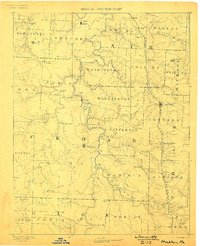
1886 Map of Stockton
USGS Topo · Published 1898About this map
The county seat of Stockton stands near the center of this Missouri landscape, which is defined by the winding course of the Sac River and its numerous tributaries. Surveyed in the mid-1880s, the map reveals a region transitioning from isolated river settlements to a rail-connected economy. The Kansas City Clinton and Springfield Railroad cuts across the eastern townships, linking communities like Humansville and Fair Play to broader markets.
Find a feature on this map
57 named features on this map. Tap any name to fly to it.
Don’t see what you’re looking for? This feature index may not catch every label — zoom into the map to look around manually.
Map Details
Editions of this 1886 Stockton Map
3 editions found
Other maps of this area

1884 · Springfield
USGS Topo · 1:125,000

1884 · Bolivar
USGS Topo · 1:125,000

1886 · Nevada
USGS Topo · 1:125,000

1886 · Stockton
USGS Topo · 1:125,000

1886 · Greenfield
USGS Topo · 1:125,000

1886 · Carthage
USGS Topo · 1:125,000

1886 · Springfield
USGS Topo · 1:125,000

1887 · Clinton
USGS Topo · 1:125,000

1887 · Warsaw
USGS Topo · 1:125,000

1887 · Butler
USGS Topo · 1:125,000