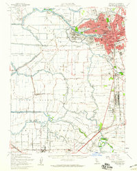
1952 Map of Stockton
USGS Topo · Published 1959About this map
The San Joaquin River and its intricate network of sloughs and cuts dominate this mid-century landscape of the Central Valley. In Stockton, the urban core is defined by the Turning Basin and the confluence of the Calaveras River and Mormon Slough, highlighting the city's role as an inland port. This period reveals a growing educational infrastructure, with both Stockton College and the College of the Pacific established near the waterfront. To the south, the industrial and military footprint is visible through the Sharpe General Depot and a Sugar Refinery near the southern boundary. The surrounding delta land is meticulously partitioned into named tracts like Union Island and Roberts Island, reflecting an era where reclaimed agricultural land was serviced by numerous rural schools including the David Bixler School and Naglee Sch. Major rail lines, including the Southern Pacific and Western Pacific, intersect at Lathrop, underscoring the region's transport importance.
Find a feature on this map
135 named features on this map. Tap any name to fly to it.
Don’t see what you’re looking for? This feature index may not catch every label — zoom into the map to look around manually.
Map Details
Editions of this 1952 Stockton Map
2 editions found
Other maps of this area

1894 · Lodi
USGS Topo · 1:125,000

1907 · Tesla
USGS Topo · 1:62,500

1908 · Waterloo
USGS Topo · 1:31,680

1910 · Castle
USGS Topo · 1:31,680

1910 · Bouldin
USGS Topo · 1:31,680

1910 · Headreach
USGS Topo · 1:31,680

1913 · Woodward Island
USGS Topo · 1:31,680

1913 · Stockton
USGS Topo · 1:31,680

1913 · Holt
USGS Topo · 1:31,680

1914 · Burnham
USGS Topo · 1:31,680