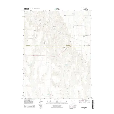
2014 Map of Stockville NE
USGS Topo · Published 2014About this map
Deep canyons carved into the Nebraska loess plains define the geography where the border of Lincoln County and Frontier County meets. The drainage of Deer Creek is the dominant natural force here, creating distinctive landforms like Mitchell Creek Canyon and East Deer Creek Canyon. This rugged terrain, often less suited for intensive agriculture than the surrounding plateaus, is nonetheless managed through several water control features including Harper Reservoir, Wintermute Reservoir, and Walther Reservoir. Local transit and land division are marked by a grid of named rural routes, such as McPheeters Rd and McNickle Rd, which follow section lines where the topography allows. Cultural history is anchored by the Saint Joseph Cem located near the junction of Farnham Rd and McNickle Road, providing a specific point of interest for genealogical research in this sparsely settled region.
Find a feature on this map
18 named features on this map. Tap any name to fly to it.
Don’t see what you’re looking for? This feature index may not catch every label — zoom into the map to look around manually.
Map Details
Editions of this 2014 Stockville NE Map
This is the sole edition of this map. No revisions or reprints were ever made.
Other maps of this area

1902 · Gothenburg
USGS Topo · 1:125,000

1954 · McCook
USGS Topo · 1:250,000

1956 · Jeffrey Reservoir SW
USGS Topo · 1:24,000

1956 · Stockville NE
USGS Topo · 1:24,000

1956 · Moorefield
USGS Topo · 1:24,000

1956 · Stockville
USGS Topo · 1:24,000

1956 · Stockville SE
USGS Topo · 1:24,000

1957 · McCook
USGS Topo · 1:250,000

1958 · McCook
USGS Topo · 1:250,000
1970 · Eustis SW
USGS Topo · 1:24,000