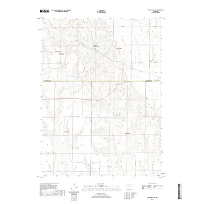
2017 Map of Stockville NE
USGS Topo · Published 2017About this map
Saint Joseph Cem sits near the crossing of Farnham Rd and McNickle Rd, marking a quiet cultural landmark on the high ground between Nebraska's deeply incised drainages. The landscape is defined by the complex erosion of the Deer Cr watershed, which carved out East Deer Creek Canyon, Mitchell Creek Canyon, and Deer Creek Canyon. This network of canyons and plateaus straddles the boundary between Lincoln and Frontier counties. Modern land use is evident in several water management features, including Wintermute Reservoir, Walther Reservoir, and Harper Reservoir. A grid of rural routes like Thomsen Hill Rd and Brushy Rd navigates the challenging topography, providing access to remote agricultural sections in this dissected corner of the Great Plains.
Find a feature on this map
30 named features on this map. Tap any name to fly to it.
Don’t see what you’re looking for? This feature index may not catch every label — zoom into the map to look around manually.
Map Details
Editions of this 2017 Stockville NE Map
This is the sole edition of this map. No revisions or reprints were ever made.
Other maps of this area

1902 · Gothenburg
USGS Topo · 1:125,000

1954 · McCook
USGS Topo · 1:250,000

1956 · Jeffrey Reservoir SW
USGS Topo · 1:24,000

1956 · Stockville NE
USGS Topo · 1:24,000

1956 · Moorefield
USGS Topo · 1:24,000

1956 · Stockville
USGS Topo · 1:24,000

1956 · Stockville SE
USGS Topo · 1:24,000

1957 · McCook
USGS Topo · 1:250,000

1958 · McCook
USGS Topo · 1:250,000
1970 · Eustis SW
USGS Topo · 1:24,000