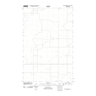
2011 Map of Stockyard Creek
USGS Topo · Published 2011About this map
Stockyard Creek defines the drainage of this prairie landscape north of the Missouri River valley. The terrain is structured by a rigid section-line road grid, with primary corridors like County Hwy 11 and Route 1804 providing the main transit across the rolling plains. Small watercourses such as Stony Creek and Long Creek cut through the geometry of the wheat fields and rangeland. This 2011 survey by the U.S. Geological Survey shows the area as it transitioned into the modern era, with named local routes like Broadway St and 57th St NW reflecting the persistence of rural homesteading patterns. The scarcity of established town centers on this specific sheet highlights the remote, agricultural character of the Williams County interior during the early 21st century.
Find a feature on this map
18 named features on this map. Tap any name to fly to it.
Don’t see what you’re looking for? This feature index may not catch every label — zoom into the map to look around manually.
Map Details
Editions of this 2011 Stockyard Creek Map
This is the sole edition of this map. No revisions or reprints were ever made.
Other maps of this area

1911 · Ray
USGS Topo · 1:125,000

1953 · Williston
USGS Topo · 1:250,000

1957 · Williston
USGS Topo · 1:250,000

1959 · Marmon SE
USGS Topo · 1:24,000

1959 · Williston East
USGS Topo · 1:24,000

1978 · Lake Jessie
USGS Topo · 1:24,000

1978 · Epping
USGS Topo · 1:24,000

1978 · Spring Brook
USGS Topo · 1:24,000
1978 · Gamache Creek
USGS Topo · 1:24,000
1979 · Chris Creek
USGS Topo · 1:24,000