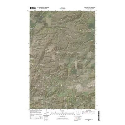
2014 Map of Stockyard Creek
USGS Topo · Published 2014About this map
Spring Brook sits at the northern edge of this high plains landscape in Williams County, where the terrain is defined by the dendritic drainage patterns of three major local waterways. The southern reaches of the map are bisected by ND-1804, a route following the historical corridors north of the Missouri River. Between the high ridges, the courses of Stony Cr, Stockyard Cr, and Long Cr carve through the prairie, illustrating the natural water management of the region before it reaches the larger river valleys to the south. The intersection of CR-11 and the sectional road grid, including 129th Ave NW and 50th St NW, shows the persistent geometric organization of North Dakota's agricultural and ranching lands. This 2014 survey records the rural infrastructure of the Williston Basin during a period of significant regional activity, capturing the precise layout of section lines and remote access roads.
Find a feature on this map
17 named features on this map. Tap any name to fly to it.
Don’t see what you’re looking for? This feature index may not catch every label — zoom into the map to look around manually.
Map Details
Editions of this 2014 Stockyard Creek Map
This is the sole edition of this map. No revisions or reprints were ever made.
Other maps of this area

1911 · Ray
USGS Topo · 1:125,000

1953 · Williston
USGS Topo · 1:250,000

1957 · Williston
USGS Topo · 1:250,000

1959 · Marmon SE
USGS Topo · 1:24,000

1959 · Williston East
USGS Topo · 1:24,000

1978 · Lake Jessie
USGS Topo · 1:24,000

1978 · Epping
USGS Topo · 1:24,000

1978 · Spring Brook
USGS Topo · 1:24,000
1978 · Gamache Creek
USGS Topo · 1:24,000
1979 · Chris Creek
USGS Topo · 1:24,000