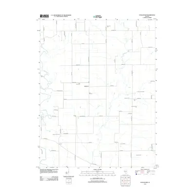
2012 Map of Stolletown
USGS Topo · Published 2012About this map
The agrarian community of Stolletown and the nearby settlement of Frogtown anchor this portion of Clinton County. The landscape is defined by the winding paths of Shoal Cr and Beaver Cr, which cut through a grid of rural roads and large-scale agricultural operations. Evidence of the region's dairy heritage is visible at the Diekemper Dairy and the Beckemeyer Dairy Farm, while several active energy sites, such as the Frogtown North Oil Field and Carlyle North Oil Field, suggest a diversified local economy beyond traditional farming. For genealogists, the map is particularly useful for locating several rural burial grounds, including Saint Felicitas Cem, Saint Peter Cem, and Rudolph Cem. In the southeastern corner, the Carlyle Airpark and the Carlyle Oil Field mark the intersection of modern transport and resource extraction amidst the flat Illinois prairie.
Find a feature on this map
58 named features on this map. Tap any name to fly to it.
Don’t see what you’re looking for? This feature index may not catch every label — zoom into the map to look around manually.
Map Details
Editions of this 2012 Stolletown Map
This is the sole edition of this map. No revisions or reprints were ever made.
Other maps of this area

1906 · Breese
USGS Topo · 1:62,500

1907 · Breese
USGS Topo · 1:62,500

1910 · Carlyle
USGS Topo · 1:62,500

1932 · Greenville
USGS Topo · 1:62,500

1937 · New Douglas
USGS Topo · 1:48,000

1939 · Greenville
USGS Topo · 1:62,500

1943 · Greenville
USGS Topo · 1:62,500

1944 · New Douglas
USGS Topo · 1:62,500

1948 · Carlyle
USGS Topo · 1:62,500

1958 · Belleville
USGS Topo · 1:250,000