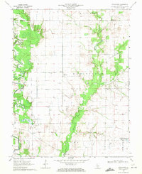
1968 Map of Stolletown
USGS Topo · Published 1971About this map
The agricultural landscape of Clinton County is defined here by the winding course of Beaver Creek and the industrial activity of the Carlyle North Oil Field. Small rural settlements like Stolletown and Frogtown anchor the local community, which is served by landmarks such as the St Felicitas Ch and the Ford Sch. The map reveals a transition in land use toward the southeast, where the edges of the Carlyle Reservoir appear, alongside the Carlyle Airpark.
Find a feature on this map
25 named features on this map. Tap any name to fly to it.
Don’t see what you’re looking for? This feature index may not catch every label — zoom into the map to look around manually.
Map Details
Editions of this 1968 Stolletown Map
This is the sole edition of this map. No revisions or reprints were ever made.
Other maps of this area

1906 · Breese
USGS Topo · 1:62,500

1907 · Breese
USGS Topo · 1:62,500

1910 · Carlyle
USGS Topo · 1:62,500

1932 · Greenville
USGS Topo · 1:62,500

1937 · New Douglas
USGS Topo · 1:48,000

1939 · Greenville
USGS Topo · 1:62,500

1943 · Greenville
USGS Topo · 1:62,500

1944 · New Douglas
USGS Topo · 1:62,500

1948 · Carlyle
USGS Topo · 1:62,500

1958 · Belleville
USGS Topo · 1:250,000