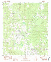
1983 Map of Stonewall
USGS Topo · Published 1983About this map
Enterprise and Stonewall anchor this section of Clarke County during the early 1980s, situated where the Chickasawhay River and its various tributaries like Weir Creek and McCants Creek carve through the landscape. The region’s industrial and transportation roots are clearly visible through the junction of the Southern Railway System and the Illinois Central Gulf, reflecting a reliance on rail for moving timber or local resources. Evidence of local industry appears at the Clay Pit northwest of Enterprise, while the Enterprise Lookout Tower stands as a sentinel over the surrounding woods.
Find a feature on this map
35 named features on this map. Tap any name to fly to it.
Don’t see what you’re looking for? This feature index may not catch every label — zoom into the map to look around manually.
Map Details
Editions of this 1983 Stonewall Map
This is the sole edition of this map. No revisions or reprints were ever made.
Other maps of this area

1921 · Meridian
USGS Topo · 1:48,000

1923 · Meridian
USGS Topo · 1:62,500

1953 · Meridian
USGS Topo · 1:250,000

1957 · Meridian
USGS Topo · 1:250,000

1957 · Chunky
USGS Topo · 1:62,500

1957 · Quitman
USGS Topo · 1:62,500

1957 · Enterprise
USGS Topo · 1:62,500

1965 · Meridian
USGS Topo · 1:250,000

1971 · Meridian South
USGS Topo · 1:24,000

1982 · Meehan
USGS Topo · 1:24,000