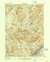
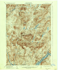
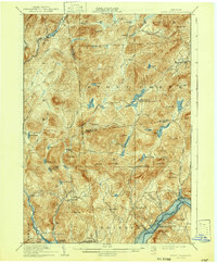
1910 Map of Stony Creek
USGS Topo · Published 1947About this map
West Stony Creek PO and the surrounding Adirondack wilderness appear here in a landscape defined by isolated settlements and early hunting camps. Surveyed before the major flooding of the Sacandaga River valley, the map documents a network of small hamlets like Hope Falls, Bakertown, and Tennantville that served the local timber and tanning industries. The terrain is marked by family-named peaks such as Rand Mtn and Georgia Mta, while the presence of locations like Wadsworth Camp and Olmstead Camp reflects the region's early 20th-century character as a destination for sportsmen. The Oregon Trail cuts across the northern reaches, a reminder of the historical migration and logging routes that once bypassed the dense interior forests near Wilcox Lake and Murphy Lake.
Find a feature on this map
86 named features on this map. Tap any name to fly to it.
Don’t see what you’re looking for? This feature index may not catch every label — zoom into the map to look around manually.
Map Details
Editions of this 1910 Stony Creek Map
7 editions found

Other maps of this area

1895 · North Creek
USGS Topo · 1:62,500

1897 · North Creek
USGS Topo · 1:62,500

1898 · Thirteenth Lake
USGS Topo · 1:62,500

1899 · Indian Lake
USGS Topo · 1:62,500

1899 · Broadalbin
USGS Topo · 1:62,500

1902 · Broadalbin
USGS Topo · 1:62,500

1902 · Saratoga
USGS Topo · 1:62,500

1902 · Indian Lake
USGS Topo · 1:62,500

1903 · Luzerne
USGS Topo · 1:62,500

1903 · Gloversville
USGS Topo · 1:62,500