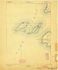
1895 Map of Stony Island
USGS Topo · Published 1900About this map
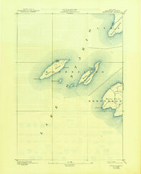
The eastern reaches of Lake Ontario are defined by this 1890s survey of the island chain and mainland points guarding the entrance to the Sackets Harbor region. Navigation is the primary theme of this maritime landscape, anchored by the Galloo Id. L.H. and Stony Point L.H. lighthouse stations. These beacons provided critical guidance for vessels maneuvering through the open water and around the treacherous shoals surrounding Galloo Island, Little Galloo Id., and Calf Id..
Find a feature on this map
14 named features on this map. Tap any name to fly to it.
Don’t see what you’re looking for? This feature index may not catch every label — zoom into the map to look around manually.
Map Details
Editions of this 1895 Stony Island Map
6 editions found
Other maps of this area

1893 · Sackets Harbor
USGS Topo · 1:62,500

1895 · Sacketts Harbor
USGS Topo · 1:62,500

1895 · Stony Island
USGS Topo · 1:62,500

1895 · Pulaski
USGS Topo · 1:62,500

1895 · Cape Vincent
USGS Topo · 1:62,500

1900 · Clayton
USGS Topo · 1:62,500

1903 · Clayton
USGS Topo · 1:62,500

1942 · Stony Point
USGS Topo · 1:31,680

1942 · Henderson Bay
USGS Topo · 1:31,680

1942 · Chaumont
USGS Topo · 1:31,680