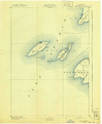
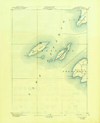
1895 Map of Stony Island
USGS Topo · Published 1940About this map
The waters of eastern Lake Ontario dominate this late-nineteenth-century survey, revealing a chain of islands and peninsulas critical to the maritime history of Jefferson County. Navigational safety is highlighted by the presence of Galloo Id. L.H. and Stony Point L.H., marking the approaches to the mainland. The internal geography of these landmasses is captured in surprising detail, from the sheltered North Pond and Gill Harbor on Galloo Island to the isolated Dutch John Bay on Stony Island. On the mainland, the township of Henderson meets the lake at the prominent Stony Point, where a sparse network of early roads connects the shoreline to the interior. This reconnaissance-level map provides a clear record of the coastline before mid-century changes, documenting the natural harbors and smaller outcroppings like Little Galloo Id. and Calf Id. that defined the treacherous waters of this island passage.
Find a feature on this map
14 named features on this map. Tap any name to fly to it.
Don’t see what you’re looking for? This feature index may not catch every label — zoom into the map to look around manually.
Map Details
Editions of this 1895 Stony Island Map
6 editions found
Other maps of this area

1893 · Sackets Harbor
USGS Topo · 1:62,500

1895 · Sacketts Harbor
USGS Topo · 1:62,500

1895 · Stony Island
USGS Topo · 1:62,500

1895 · Pulaski
USGS Topo · 1:62,500

1895 · Cape Vincent
USGS Topo · 1:62,500

1900 · Clayton
USGS Topo · 1:62,500

1903 · Clayton
USGS Topo · 1:62,500

1942 · Stony Point
USGS Topo · 1:31,680

1942 · Henderson Bay
USGS Topo · 1:31,680

1942 · Chaumont
USGS Topo · 1:31,680