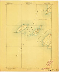
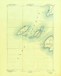
1895 Map of Stony Island
USGS Topo · Published 1907About this map
Galloo Island and Stony Island anchor this hydrographic study of eastern Lake Ontario, reflecting the maritime geography of Jefferson County in the late nineteenth century. The map focuses on the navigation hazards and landing points of these offshore landmasses, including the enclosed waters of North Pond and the sheltered Gill Harbor. The isolation of these outposts necessitated the operation of vital navigational aids, specifically the Galloo Id. L.H. and the Stony Point L.H. on the mainland. On Stony Point, a sparse network of roads indicates the early rural development of Henderson and Lyme. This 1893 survey serves as a precise record of the shoreline and shoals before modern dredging and commercial development altered the eastern lakefront.
Find a feature on this map
14 named features on this map. Tap any name to fly to it.
Don’t see what you’re looking for? This feature index may not catch every label — zoom into the map to look around manually.
Map Details
Editions of this 1895 Stony Island Map
6 editions found
Other maps of this area

1893 · Sackets Harbor
USGS Topo · 1:62,500

1895 · Sacketts Harbor
USGS Topo · 1:62,500

1895 · Stony Island
USGS Topo · 1:62,500

1895 · Pulaski
USGS Topo · 1:62,500

1895 · Cape Vincent
USGS Topo · 1:62,500

1900 · Clayton
USGS Topo · 1:62,500

1903 · Clayton
USGS Topo · 1:62,500

1942 · Stony Point
USGS Topo · 1:31,680

1942 · Henderson Bay
USGS Topo · 1:31,680

1942 · Chaumont
USGS Topo · 1:31,680