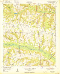
1950 Map of Storys Millpond
USGS Topo · Published 1950About this map
Brier Creek winds through the heart of the central Georgia landscape, defining the rural character of this post-war environment. The area is marked by a network of local roads such as Winter Road and Walkers Bridge Road, which connect a series of small, community-centered institutions. A significant density of rural churches and schools suggests a tight-knit agrarian social structure, featuring landmarks like Spreadoak Church, Richmond Hill Church, and Winters School. The topography is shaped by numerous ponds and branches, including Storys Millpond and Goldberg Pond, which highlight the importance of water management for local industry or agriculture. Researchers will also find the Hammond Academy and established family-named landmarks like Gresham Cemetery, providing valuable points of reference for local genealogical studies in this portion of the Richmond and Burke County line.
Find a feature on this map
36 named features on this map. Tap any name to fly to it.
Don’t see what you’re looking for? This feature index may not catch every label — zoom into the map to look around manually.
Map Details
Editions of this 1950 Storys Millpond Map
2 editions found
Other maps of this area

1919 · Gough
USGS Topo · 1:62,500

1920 · Greens Cut
USGS Topo · 1:62,500

1921 · Augusta
USGS Topo · 1:62,500

1922 · Hephzibah
USGS Topo · 1:62,500

1943 · Greens Cut
USGS Topo · 1:62,500

1943 · Augusta East
USGS Topo · 1:125,000

1943 · Augusta
USGS Topo · 1:62,500

1948 · Hephzibah
USGS Topo · 1:62,500

1948 · Gough
USGS Topo · 1:62,500

1948 · Blythe
USGS Topo · 1:24,000