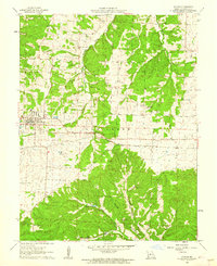
1961 Map of Stover
USGS Topo · Published 1962About this map
Stover sits as the central hub of this 1961 survey, where the Chicago Rock Island And Pacific railroad cuts a straight line through the undulating terrain of Haw Creek township. The landscape is a mix of agricultural clearings and dense woodlands, drained by the northern-flowing Richland Creek and its tributary, Middle Richland Creek. This area of Morgan County reflects a deep-rooted rural community, evidenced by numerous local burial grounds such as Hinken Cem and Antioch Cem, and community landmarks like Mt Nebo Ch.
Find a feature on this map
18 named features on this map. Tap any name to fly to it.
Don’t see what you’re looking for? This feature index may not catch every label — zoom into the map to look around manually.
Map Details
Editions of this 1961 Stover Map
3 editions found
Other maps of this area

1887 · Sedalia
USGS Topo · 1:125,000

1887 · Warsaw
USGS Topo · 1:125,000

1888 · Versailles
USGS Topo · 1:125,000

1888 · Boonville
USGS Topo · 1:125,000

1893 · Versailles
USGS Topo · 1:125,000

1894 · Warsaw
USGS Topo · 1:125,000

1894 · Sedalia
USGS Topo · 1:125,000

1904 · Gravois Mills
USGS Topo · 1:62,500

1935 · Gravois Mills
USGS Topo · 1:24,000

1935 · Proctor Creek
USGS Topo · 1:24,000