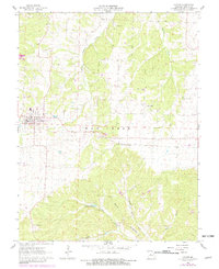
1961 Map of Stover
USGS Topo · Published 1982About this map
Stover serves as the central hub of this Missouri landscape, situated where the St Louis Southwestern railroad corridor cuts across the Haw Creek township line. The surrounding countryside is marked by a network of rural institutions and early industrial sites, including the Gabriel Mine to the north and the Wolf Den Mine near the southern edge. The rugged geography of the Ozark foothills is evident in the winding courses of Middle Richland Creek and Devils Backbone Creek, with local landmarks like Spears Cave and Crystal Lake punctuating the terrain.
Find a feature on this map
22 named features on this map. Tap any name to fly to it.
Don’t see what you’re looking for? This feature index may not catch every label — zoom into the map to look around manually.
Map Details
Editions of this 1961 Stover Map
3 editions found
Other maps of this area

1887 · Sedalia
USGS Topo · 1:125,000

1887 · Warsaw
USGS Topo · 1:125,000

1888 · Versailles
USGS Topo · 1:125,000

1888 · Boonville
USGS Topo · 1:125,000

1893 · Versailles
USGS Topo · 1:125,000

1894 · Warsaw
USGS Topo · 1:125,000

1894 · Sedalia
USGS Topo · 1:125,000

1904 · Gravois Mills
USGS Topo · 1:62,500

1935 · Gravois Mills
USGS Topo · 1:24,000

1935 · Proctor Creek
USGS Topo · 1:24,000