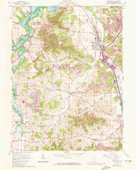
1961 Map of Strasburg
USGS Topo · Published 1961About this map
Sugar Creek winds through this portion of Tuscarawas County, defining the valley landscape around Strasburg and Dundee. The industrial character of the early 1960s is evident in the numerous Strip Mine operations and the extensive rail infrastructure, including the Norfolk and Western and Baltimore and Ohio lines that serve the local communities. The northern reaches are dominated by the Beach City Reservoir, part of the MuskingUM Watershed Conservancy District, which altered the natural flow of the South Fork Sugar Creek. Rural life is centered on family-named landmarks and local institutions like Mt Zion Ch, Bunker Hill Ch, and the Grandview Cem. Smaller settlements such as Winfield, Beartown, and Barrs Mills are connected by a network of winding roads and runs, including Cherry Run and Brandywine Creek, illustrating the intersection of natural drainage and human habitation.
Find a feature on this map
50 named features on this map. Tap any name to fly to it.
Don’t see what you’re looking for? This feature index may not catch every label — zoom into the map to look around manually.
Map Details
Editions of this 1961 Strasburg Map
3 editions found
Other maps of this area

1909 · Uhrichsville
USGS Topo · 1:62,500

1911 · Uhrichsville
USGS Topo · 1:62,500

1911 · Newcomerstown
USGS Topo · 1:62,500

1912 · Dover
USGS Topo · 1:62,500

1913 · Newcomerstown
USGS Topo · 1:62,500

1914 · Navarre
USGS Topo · 1:62,500

1943 · Newcomerstown
USGS Topo · 1:62,500

1944 · Navarre
USGS Topo · 1:62,500

1944 · Dover
USGS Topo · 1:62,500

1951 · Canton
USGS Topo · 1:250,000