1945 Map of Stratford
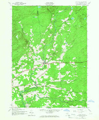
USGS Topo · Published 1966About this map
Adirondack State Park land dominates the landscape of the southern Adirondack foothills in the mid-1940s, split by the winding course of East Canada Creek. The small settlement of Stratford serves as a central point for a network of country roads connecting isolated hamlets like Knappville and Emmonsburg. This geography reflects a period of transition where local water resources, such as Knapp Reservoir and Stony Brook Lake, supported both small-scale industry and the expanding state park system. Genealogists can find important family landmarks including School No 10 and the Roundtop Cem, while the inclusion of an Aqueduct and Substation near Sprite Creek points to the infrastructure development of the era. The terrain transitions from the high peaks of Oak Mtn and Bear Hill down to the creek valleys where Bliss Corner marks a junction in the agricultural and forested landscape.
Find a feature on this map
31 named features on this map. Tap any name to fly to it.
Don’t see what you’re looking for? This feature index may not catch every label — zoom into the map to look around manually.
Map Details
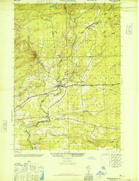
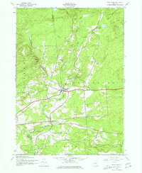
Editions of this 1945 Stratford Map
4 editions found

Other maps of this area

1900 · Little Falls
USGS Topo · 1:62,500

1900 · Wilmurt
USGS Topo · 1:62,500

1901 · Lassellsville
USGS Topo · 1:62,500

1902 · Wilmurt
USGS Topo · 1:62,500

1903 · Lassellsville
USGS Topo · 1:62,500

1903 · Little Falls
USGS Topo · 1:62,500

1904 · Piseco Lake
USGS Topo · 1:62,500

1906 · Piseco Lake
USGS Topo · 1:62,500

1908 · Piseco Lake
USGS Topo · 1:62,500

1939 · Little Falls
USGS Topo · 1:62,500